Highland Glen Trails


Highland Glen


Highland Glen


Note: For wintertime use, refer to our Sunset Hills & Highland Glen Nordic page.
Length: 1-6 miles
Duration: 20 minutes to 2 hours
Difficulty: Easy
Elevation Gain: 100-200 feet
Activities: Hiking, trail running, mountain biking, cross-country skiing
About
Highland Glen Nature Preserve sits right within Bozeman's city limits between the hospital and Kagy Blvd. A big thanks to GVLT and Bozeman Health for partnering to preserve this land as area and wildlife-habitat area.
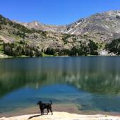
The trails in Highland Glen are very smooth and well maintained, weaving their way through lush, grassy meadows with occasional steeper gullies near creek beds to offer some up-and-down action. There are many different ways to connect trails within the preserve, so you can choose your own path and change it up each time you go. At the preserve's southern access point on Kagy, it's convenient to link these trails with the Painted Hills trail, which in turn can be linked with the Triple Tree trail for a 15-mile lollipop loop on singletrack the entire way, starting right off Main Street downtown. Now how's that for access?
Seasonal Conditions
Highland Glen's trails generally dry out pretty early in the spring, but if there's been a lot of rain, the trails can get very muddy—help keep the trails nice and smooth by avoiding them until they're dry!
In the winter, Bridger Ski Foundation grooms several Nordic trails through Highland Glen, connected to the Sunset Hills network. More info on these Nordic trails here.
Directions
There are three main access points for the Highland Glen Trails: from the north near the hospital and softball complex (lots of parking available at the softball complex), from the west on Highland Blvd. across from Peets Hill, and on the south on Kagy Blvd. across from Painted Hills. Whether you're walking, biking, or driving, you should be able to easily find these access points, perhaps with the help of a passerby.

Map courtesy of GVLT