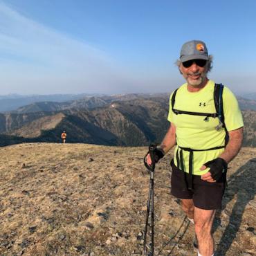


An aging mountain climber returns to Montana's highest peak.
There are three approaches to Montana’s highest point. None of them are short, none of them are easy. At 12,799 feet, Granite Peak is steep, stormy, and well-ensconced inside the 943,648-acre Absaroka-Beartooth Wilderness. On my first attempt to summit the mountain 40 years ago, three 20-somethings—Rune, Al, George—and I backpacked into Princess Lake. We did a reconnaissance trip to Avalanche Lake after setting up camp on the lakeshore, and were impressed by the difficulties that we faced in the morning. Still, we were young, confident in our abilities, and out as much to have fun as to climb. We should have known better.
We rolled out of bed late and didn’t get going until nine. We hung out too long at Avalanche Lake while Al and George got their fill of fish, then Rune and I started off. George eventually pulled himself away from the fish and caught up, but Al couldn’t bear to leave the action.
We summited in late afternoon as thunder boomed. On the descent, we were caught out after dark on a moonless night. We had to crawl through the boulder fields bounding the Snowball Lakes. Al had waited for us at Avalanche Lake, and he crawled with a string of tasty fish the whole way back to camp.
Realistically, will I ever, attempt it again? Would things end up any differently if I got lucky and was there on a bluebird day?
In the years since, I attributed our near disaster on Granite to youthful hubris. So when Chris, my son-in-law, asked if I wanted to attempt Granite again—this time as a day trek using the Froze-to-Death Plateau for an approach route—I jumped at the idea. We are both dedicated trail runners, and we both put in concerted efforts to stay in shape. We would go early, go light, and go fast; we’d make quick work of Granite and get out of there before the afternoon thunderheads bloomed. This proved to be easier said than done.


We endured lung-searing smoke early in the day as we climbed to the plateau, then a long and difficult trek across boulder fields and alpine tundra to reach the plateau’s western edge. The descent to the saddle between Granite Peak and Tempest Mountain cuts an angle across the roughly 30-degree face of Tempest while dropping 620 vertical feet. It’s one long, tilted boulder field. We crossed and made it to the saddle at 2pm, only two hours earlier than Rune and I had made it 40 years before.
The climb from the saddle to the next major obstacle—a snow bridge—is a challenging 800-foot ascent with plenty of class-three and some class-four scrambling. The snow bridge itself is a route across a couloir that drops steeply down the south side of Granite, which must be “bridged” near its top at 12,250 feet. I was slower than Chris. He was about 20 minutes ahead when I crossed the snow bridge and reached the last, most dangerous part of the climb. I started up, remembering how exposed my younger self had felt in the same spot. Rappelling slings that were scattered about did nothing to relieve my sense of exposure. Clouds were building, as was the sense that I may be too old for this. I paused, looking up at the chimney looming overhead. Forty years earlier, a storm threatened me on the same part of the peak. I’d gotten lucky then, as the storm had held off. But I was slower now. Would I be as lucky this time? I chose not to find out.
I can’t say with any certainty which is more challenging: crossing Froze-to-Death and the face of Tempest, or hopping across endless boulders around Snowball and Avalanche lakes.
I radioed Chris that I was turning back. He continued to the top then raced back down. The storm caught him on the snow bridge. I was at the saddle when it finally overtook my position. It was cold. I kept moving, expecting that it would be a short afternoon thunderstorm and we would reconvene at the edge of Froze-to-Death.


The storm produced hail, then wind-driven wet snow, making the crossing to Froze-to-Death all the more treacherous. A lightning bolt flashed directly ahead of me, creating a fully enveloping and altogether deafening thunderclap. I completed the crossing and started shivering as soon as I stopped at the top to wait for Chris. We radioed; he had gotten lost in the fog, was back on track, but was still descending to the saddle. I decided to climb 12,478-foot Tempest in the storm. It was an easy hike from the saddle, and a better option than trying to stand still and possibly freezing to death on the inauspiciously named plateau.
Tempest was fogged in when I reached the top. I got up and down before Chris reached the plateau, but started shivering as soon as I stopped moving. I radioed him: “Follow my footprints through the snow,” and started off in search of cairns to guide us in the vast, unyielding hellscape. Chris appeared on the plateau five minutes later. We reconvened and pushed on.

The Tempest
The wind was incessant, but the snow abated and the temperatures warmed as we descended nearly 2,000 feet to the base of the plateau. It seemed impossibly vast as we trekked across it. We were moving well, but hours kept rolling by.
It was 8:45pm when we finally dropped off the plateau and found the trail. With the forest providing protection from the wind, it got warmer, but now the race was on to beat darkness.


We ran down the 26 switchbacks to Mystic Lake, arriving just as the darkness fully folded in. Forty years earlier, when Rune, George, Al and I got caught out in the dark, none of us had brought a flashlight; they were excess weight as they couldn’t be eaten (at least that had been our opinion back then). We’d attempted to be prepared, but Chris’s headlamp had failed that morning and was left behind. I had taken my headlamp out of my pack at the top of the switchbacks only to leave it on the ground as we hurried on our way. Our only light source was Chris’s iPhone flashlight. How long would it last?
Chris was about 20 minutes ahead when I crossed the snow bridge and reached the last, most dangerous part of the climb. I started up, remembering how exposed my younger self had felt in the same spot.
We reached the car at 11:15pm. It had been a 16-hour day. We had traveled 27.3 miles and climbed 8,700 feet. Both of those stats were records for me—it was my first ultramarathon—while Chris, a veteran of endeavors of this magnitude, saw it as a “good training day.” By all accounts, the route—even with my addition of Tempest, had been longer than expected based on all the guidebooks and trip reports I had read in preparation. As Chris put it, “they sandbagged us.”

I see now that it wasn’t just youthful exuberance that had gotten us caught out in the dark 40 years ago. That had certainly contributed, but the approaches to Granite are long and difficult. Between the Froze-to-Death and Princess Lake routes, I can’t say with any certainty which is more challenging: crossing Froze-to-Death and the face of Tempest, or hopping across endless boulders around the Snowball and Avalanche lakes. The former is longer, but on the latter, one faces more relentless boulder fields. There is, however, another approach to Granite—from Sky Top lakes to the south. The route stays high on the rocks paralleling the snow bridge couloir, but it’s still a long approach and one must face the same dangers above the snow bridge. Perhaps on my next attempt, I’ll try that route.
But will I ever, realistically, attempt it again? And would things end up any differently even if I got lucky and found myself out there on a bluebird day? I don’t know. I’d like to think I’d be carrying ropes, harnesses, and rappelling equipment, but no matter the approach, it’s a long way to carry all that gear. Regardless, a headlamp will be in my backpack next time, from start to finish.