All Along the Waterfront


There’s a sweet spot in the fall, unfolding as subtly as a turning leaf. Seasonal crowds dwindle, but the days are still pleasant. Weather starts to change, but cool nights under a sleeping bag offer some of the best sleep of the year. Mornings yield crisp air, and light fog lingers without a mosquito in sight. The world is still again.
No doubt, this precious time is fleeting, and we must find a way to make the most of it. Waterfront campgrounds, while bustling in summer, offer serenity and solitude come fall. Sip coffee on the bank in the morning and take your last swim of the year in the afternoon. Wander the woods under a golden sun and let the river’s soft murmur lull you to sleep at night. Whether you hunt, fish, bike, or climb, take it to the water this fall—Bozeman’s waterfront campgrounds are beckoning.
Varney Bridge
Waterbody: Madison River
Distance from Bozeman: 60 miles
Popularity: Moderate
Activities: Hunting, fishing, floating

Fall in Montana evokes profound nostalgia—glassing a silhouetted bull elk at sunset, fighting a trout during the October baetis hatch, and heading out on the annual family hunting trip are a few things that come to mind. There’s a wistful touch to the air, growing stronger as the leaves turn color. And few places rouse this feeling more than the rustic vistas of the Madison Valley.
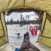
South of Ennis, the first opportunity to cross the river comes as a truss-framed overpass known as Varney Bridge. On the east side of the Madison, there’s a sliver of state land with a boat launch and room to spread out. With the right weather, the ground is perfect to set up a basecamp for a weekend cast-and-blast.
Much of the area surrounding the river is private, so make sure you have a map with up-to-date ownership. If you’ve got a watercraft, this is a good place to use it. Bigger vessels like rafts, driftboats, and canoes are best, especially if you run into game.
Upstream, the McAtee access site is a good put-in, allowing public access throughout the float back to camp. Rise early, set up on a piece of BLM, and you might have incoming birds all morning. If you don’t have decoys, the ditches can make for fun jump-shooting and fly-bys. Pack your rifle or bow and keep an eye out for deer along the river. Scouting from the boat can be quite effective. If you spot one on public land, pull into an eddy and plan your stalk.
If elk is your quarry, you’ll have better luck leaving the river. Access to the Gravelly Range is west of the bridge. Though you’re likely to have company, there’s a reason for it (read: loads of elk), and if you’re willing to work, there’s space to be found. Along with elk and deer, this area is prime grizzly habitat—there were three separate attacks just last year—so carry bear spray and plan accordingly.
Ungulates are most active at first and last light, which gives you plenty of opportunity for fishing in between. That’s the beauty of Varney: planned right with a bit of good fortune, you could have tenderloins or duck breast over the fire, and a fish on the line. You’re not far from Ennis either, should you need to resupply or stop in at Willie’s for a celebratory whiskey after punching your tag. —Corey Hockett
Mallard’s Rest
Waterbody: Yellowstone River
Distance from Bozeman: 40 miles
Popularity: Moderate
Activities: Floating, fishing, swimming, wildlife watching

Montana isn’t the same place it was 20 years ago. Trailheads previously empty are now packed full, once-rough dirt roads are now graded and easy to navigate, and vacant campgrounds have been replaced with Reservations Only signs and out-of-state plates. Indeed, Bozeman has been discovered and there’s no going back. But, as with most things in life, there is still ebb and flow, and as popularity increases, its lulls await us come the off-season. While Mallard’s Rest may see more than its share of visitors in the summer, this sprawling, picturesque riverside campground may be the perfect place to find some elbow room on a fall camping trip.
Halfway between Livingston and Emigrant, a gravel road peels off Hwy. 89 and dives down a giant cutbank to meet the Yellowstone at a magnificent bend in the river. Here, take your pick from one of 13 designated campsites. Paradise Valley is notoriously windy, but due to its uniquely tucked-away position, Mallard’s Rest can be pleasantly devoid of the typical Park County gale.
You’ll have no shortage of views here, with the Western Beartooths dominating the eastern skyline and renowned Emigrant Peak standing proud to the south. And in the fall, the towering cottonwoods lining the riverbank will no doubt shimmer in golden, prismatic fashion.
Bring your rod, and boat if you’ve got one. While you can fish from the bank along the campground, the Yellowstone is revered for its floating potential. There’s no lack of additional access sites or pull-outs to put in or take out, either. Head upstream to Grey Owl or Emigrant West and float down to camp, pounding the banks along the way with streamers or spinners. Or, leave a rig downstream and set off from camp after breakfast. Carter’s Bridge is a classic takeout, and those who want a little longer float can continue on through Livingston to Mayor’s Landing. When floating this lower section, though, keep your wits about you going under the Ninth Street Bridge—concrete pylons have been known to break oars and even take lives.
Most of the water on the Yellowstone is friendly, however. It’s a gentle giant with room to move and fish to catch. On your way through Livingston, stop at Neptune’s to fill a growler or head to Emigrant for some BBQ at Follow Yer’ Nose. Dine in or take your meal down the road to camp, where the gentle lull of the river and color of its banks are sure to clear your head and take you back to quieter times. —Corey Hockett
Spire Rock
Waterbodies: Storm Castle Creek, Gallatin River, Rat Lake
Distance from Bozeman: 25 miles
Popularity: Moderate
Activities: Fishing, boating, hiking, biking, hunting, rock climbing

Situated on the banks of Storm Castle Creek, Spire Rock Campground offers a plethora of fall activities both on and off the water. Start off your morning with a one-mile walk to the Gallatin and pound the pocket-water with nymphs and dry flies. Just upstream, the Mad Mile offers convenient whitewater laps on a stretch of sustained Class II-III rapids—just bring a helmet, as it’s sure to be bony come fall. Flatwater fans can hike up to Rat Lake and launch a paddleboard, packraft, or tube for casual floating and fishing surrounded by a dense forest of spruce and fir.
In the afternoon, warm up from the water with a selection of hiking trails, most of which include spectacular views over Gallatin Canyon and into the Spanish Peaks. The Storm Castle Trail ascends the prominent limestone bluff atop Storm Castle Peak. Across the creek, the Garnet Mountain Trail climbs to an old fire lookout atop Garnet Mountain, which is available to rent. This trail offers a rewarding out-and-back challenge for strong-legged mountain bikers, with smooth, tacky dirt for an excellent uphill workout, and a descent that will have you grinning ear to ear.
Masochistic trail runners will thrive among the many ridges sweeping up from Storm Castle Creek into the heart of the Gallatin Range. Stitch together a link-up of Garnet, Rat Lake, Mica Ridge, and Telephone Ridge. Or, jog up Storm Castle Creek Trail to access the Gallatin Crest and dash along alpine ridgelines towering over Paradise Valley.
By the evening light, don your upland vest and peruse the slopes of the upper Storm Castle Creek drainage for mountain grouse. This zone is also prime habitat for elk and mule deer, so plan ahead and get your tags if you’re looking to stock the freezer for winter.
If you’re more into pulling on crimps than pulling the trigger, the Scorched Earth crags provide quality limestone sport climbing concentrated in the 5.10-5.12 range. From steep pockets to technical slabs, the southwest aspect of Scorched Earth brings pleasant climbing temps late into the fall season.
Make sure to stop for a burger and brew at Stacey’s in Gallatin Gateway on your way back into town. This old-time watering hole has been around since the end of prohibition in 1937—we’ll drink to that. —Jack Taylor
Fairy Lake
Waterbody: Fairy Lake
Distance from Bozeman: 30 miles
Popularity: High
Activities: Hiking, biking, fishing, swimming, wildlife-watching, hunting

We all know summer winds down in September and long days of sunshine are traded for cool nights of autumn’s breeze. However, some places hold out longer than others.
This fall, extend your summer and take a mini-vacation to Fairy Lake for a weekend chock-full of outdoor fun. The northern Bridgers have plenty of multi-sport combinations to dream up, and more than one pleasant campsite to return to at the end of the day. For a basecamp, look for dispersed camping along the road, or, take it all the way to the designated campground near the lake and settle in for a re-run of summer. The road is a test for vehicles, so make sure to take a rig with high clearance.
If mountain biking is your jam, jump on your bike and head north from the lake up the steep ascent of Shafthousefor incredible views of the Bridgers and a sweeping look over the Shields Valley. When you’ve taken it all in from the top, enjoy a swift, active ride down the lightly-used singletrack. It’s best to leave a shuttle vehicle at the end, as the return trip is somewhat less enjoyable on two wheels.
If you prefer your feet over knobby tires, go the other direction and head up Sacajawea Peak—the trail takes off right from the campground. The hike is moderately difficult, but it’s short, and the payoff is worth it. Stand atop the Bridgers’ tallest summit with views of the valley and, if you’re lucky, mountain goats galore. For a longer jaunt, continue south to Naya Nuki Peak, or head back down to the saddle and scramble up Hardscrabble on the north side. Heck, take another few hours and scout Frazier Basin for the coming ski season. But no matter your hiking choice, the best part of it all comes back at the base. A sunny fall day will have you yearning for a swim, and the drop in elevation will make the temps seem even warmer. Arrive back to camp, jump in the lake, and take a few rides on the rope swing. After you’ve soaked up all the fun at Fairy Lake, make your pilgrimage back to town. But before you completely close the door on the weekend,stop by the Bozone to top off your trip. —Cordelia Pryor
Map Out Your Future
However you choose to fill your fall season—casting, blasting, boating, climbing, biking, fishing—every great outing starts, or shouldstart, with a map. As you and your friends spread it across the table and gather ‘round, boundless opportunities appear. A good map reveals every terrain feature, trail, and access road—and no map better expands your recreational boundaries than South Central Montana from Basin and Range Mapping. This is the same cartography outfit you’ve come to know and love for the Beartooth Publishingseries of outdoor-recreation maps and guidebooks.

South Central Montana, however, is meant to be mounted on the wall—so you can get a bird’s-eye view and literally put a pinin all your adventures. With public/private boundaries, permitted recreation, and more, this map is not only appealing visually, but it’s an immensely practical tool for mapping out your future days afield. For info and ordering, visit basinandrangemap.com. —Cordelia Pryor