Beehive Peak


The second-highest point in the Spanish Peaks is neither named nor assigned an elevation on any National Forest or USGS map. Yet, Beehive Peak, also known as “The Beehive,” is one of the most prominent and striking summits in the range when viewed from Ennis, Lone Mountain, and Highway 191 south of Big Sky. Beehive is particularly impressive from Ennis, where it appears as the sharp culmination of the 12-mile-long ridge that climbs gradually southeastward from Ennis Lake. This impressive escarpment, which delineates the Spanish Peaks thrust fault, rises over 3,000 feet out of Jack Creek. The name “Beehive” evidently comes from the peak’s thimble shape, but instead of attaching the name to the peak, locals officially applied that name to a lake and drainage north and south of the peak. First labeled on the 1934 Gallatin National Forest map, Beehive Lake lies at the very head of the Spanish Creek south fork. Beehive Basin is a northern tributary of the middle fork of the west fork of the Gallatin River.
Little is known about early ascents of Beehive, but local ranchers and adventurers undoubtedly climbed it long before modern mountaineers discovered the peak’s great technical climbing and glissé potential. Bozeman mountaineer Dave Wessel made the earliest known ascent in the early 1950s, and Ward Thompson recorded another ascent in 1957. After Terry Johnson installed the summit register on July 23, 1967, seventeen climbers had signed the register by September of that same year. However, it was not until 1976 that climbers began establishing rock climbs on the southeast wall of Beehive and on The Prow, an impressive gneissic tower at the head of Beehive Basin. Jack Tackle and Craig Zaspel were the first to claim routes on both of these formations, which sport many superb routes up to 5.11 in difficulty with short and easy approaches.
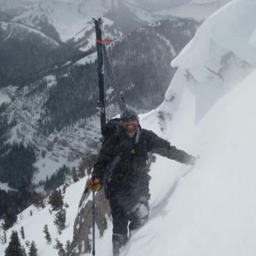
Wessel also made an early ski tour to the head of Beehive Basin in the early 1950s, paving the way for climbers and other skiers to frequent the peak in winter and spring through the 1970s. Rick Reese made an early winter ascent with Bill Lang and Wayne Phillips in the late 1970s. Emil Tanner and Doug Coombs climbed the mountain during Easter of 1978, setting off a spooky wet-slab avalanche near the top. Tanner and Coombs returned each spring of 1979, 1980, and 1981, sometimes with Tom Jungst and Jim Conway to ski couloirs on either side of the sheer southeast face, as well as on the east side of the south ridge, and south side of the east ridge. Jungst was no stranger to Beehive Peak during the late 1970s and 1980s. With Pat Callis, Mike Stiff, and others, he established several rock routes on the southeast face beginning in 1978. Regarding his route with Callis, Jungst wrote:
In all fairness, the line Pat and I worked on for so many years, and that legend has now called the “Callis-Jungst 5.11,” we never completely freed. We did free climb a bunch of lines always trying to make the most direct line through this one particular bulge. One day I tried and tried and yielded the sharp end to Pat who used a couple points of aid finally. I cleaned the munge out of the cracks lowered down and freed it. We always free climbed either side of this one spot, but like most alpine climbs the face has a zillion options… It was like we were narrowing it all down to one line. Pat insists we must free that some summer as it has gone down in guides of various forms and certainly in legend… Maybe next summer—I’ll be 45 and he 65! So we have climbed together 25 years and that project should be put to rest.
Jungst’s first ski trip to Beehive was in March 1980 with his brother Dave, who tackled the main southwest couloir and several other couloirs along the south ridge with free-heel equipment. However, Tom had his sights on the summit. While Dave began his descent at the top of the southwest couloir, Tom climbed the steep snow chutes and hanging ramps to the summit before clicking into his skis, and perhaps made the first descent from the summit. The following August, Jungst approached Beehive from Spanish Creek with Conway and Marty Bleck to ski the northerly of two Twin Couloirs on the northwest side of the peak.
Since then, ski mountaineers such as Hans Saari, Kris Erickson, and Chris Bowman have skied the southerly Twin Couloir as well as Jungst’s northerly one. According to Saari, these couloirs begin as one chute, and then split into two. Saari skied the southern one twice, reporting “an ice bulge in the choke” in low-snow years. The classic northern chute is longer, steeper, and more popular than the southern chute. The best ski line off Beehive is Bowman’s north couloir, which he skied in the mid-1990s. Dropping off the west ridge a short distance from the summit, this extreme route follows a steep ramp-like couloir for several hundred feet to the edge of a cliff. It then traverses east across a hanging snowfield to a large bowl above Beehive Lake. Mountaineer Terry Johnson first climbed this route on July 23, 1967 and named it “Hanging Garden.”
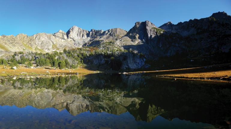
Ascent: To approach Beehive Peak, drive one mile past Big Sky Mountain Village and turn right 100 yards short of the pass into Jack Creek. Follow this road for two miles across an unsightly clear-cut hillside, through a subdivision of luxury homes, past an entry into the Summit View gated community, and park at Beehive Basin trailhead. Hike along this good trail for four miles to a beautiful meadow with a shallow lake. From the north end of the lake near a pink granite slab, strike off-trail over a low moraine and follow a small creek toward the southeast face of Beehive.
The large beehive-shaped southeast face is bound by two couloirs. The left-hand couloir often holds firm snow or ice well into summer and climbs steeply for several hundred feet from the talus to the west ridge. Slabs and loose rock on either side of the couloir may be climbed to avoid the snow, but this route is not to be taken lightly. From the notch at the top, climb an obvious ‘V’ chimney (5.2) or drop to the north and ascend an easier but looser gully. Both routes lead to the same ramp system that spirals up and right around the summit block. A short easy scramble from the ramp in a chimney leads to the summit. The couloir on the right or east side of the steep southeast face often melts free of snow sooner than the western one and leads to a very obvious notch in the east ridge several hundred yards from the summit. From the notch, the east ridge provides one of the most fun easy-Class-5 routes in Greater Yellowstone, with much exposure. Most of the climbing is done right on the ridge top with little room for error. Approximately halfway to the summit, the crux involves a windowsill ledge and steep exposed climbing (5.3). The rest of the way to the summit involves much exposed scrambling with several tricky traverses and steps. A plaque on the summit was placed in memory of Kit Jones, who was killed while climbing in 1966. Beehive Peak was Jones’ first summit and the climb that hooked him on mountaineering.
Beehive Peak Stats
Peak elevation: 10,742 feet
Beehive Basin parking elevation: 7,900 feet
Elevation gain: 2,842 feet
Distance: 5.5 miles
Overall grade by southwest couloir: II Class 4
Estimated ascent time: 3 to 5 hours
Maps: Lone Mountain
Photos by Steve Harvey, Wild West Photos, Thomas Turiano
This is an excerpt from Select Peaks of Greater Yellowstone: A Mountaineering History and Guide, published by Indomitus Books. For more information, visit selectpeaks.com.