Wild Heart

Across the Gallatin Range.
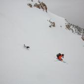
Crossing the corniced ridge, my ski partner Zach Altman and I looked down on the transitioning land. In the valley, brown gave way to green while snow blanketed the crest; spring wouldn’t be long from the high country. Over the next two days, we would leave our solitary tracks along the ridgeline stretching away in the distance.
As a resident of Bozeman, my home range is the Gallatins. I’ve logged countless miles in these mountains extending south from Hyalite Canyon, which has lent me a unique appreciation of our shared landscape. Now, for the first time in 30 years, the Custer-Gallatin National Forest is reviewing how they manage that landscape.
Most of the Gallatin Range has been protected in the boundaries of the Hyalite–Porcupine–Buffalo Horn Wilderness Study Area (WSA) since 1977. WSAs are managed specifically to retain their Wilderness characteristics. Under the new Forest Plan, the Forest Service can recommend official Wilderness designations to Congress. To gain a better understanding of the landscape under review, Zach and I set out to traverse the Gallatin Range from the border of Yellowstone National Park north into Hyalite Canyon.
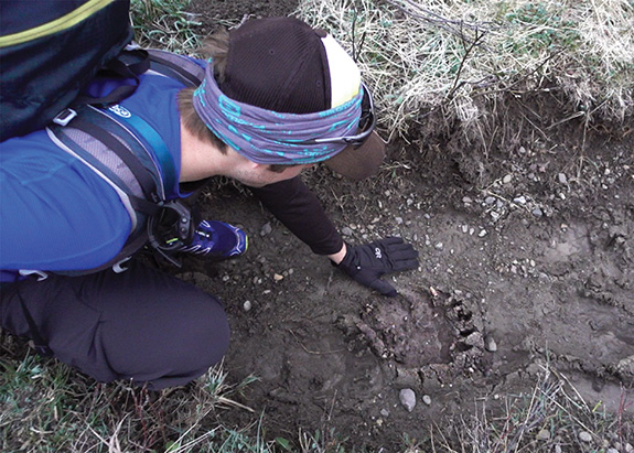
After a late-season snowstorm blanketed the high country, we set off under dark skies toward snowline. A few miles from the Gallatin River, we crossed our first set of grizzly tracks, set deep in the mud. With the edges of the claws forming frost, the bears were only hours ahead. Working our way up Ramshorn Creek and into the heart of the WSA, we continued to share our route with bears, coyotes, and wolverines. The Gallatin Range isn’t just our home; these creatures thrive here too because of the wild and roadless core.
By mid-morning, we reached our first pass high above Tom Miner Basin. From this point on, our path would follow the winding ridgeline for nearly 30 miles north toward Hyalite Peak. Over the next two days, we would only leave the ridgeline when we were lost or enjoying untracked lines back into the valley.
The first obstacle along the Gallatin Crest was Ramshorn Peak. Dropping north of the summit, we scratched our way down an icy face. Clearing the bottom of the bowl, the crust broke and I plunged head-over-heels; Zach hooted and hollered from above—then it was his turn.
By evening, with fading spirits and fading light, we reached Windy Pass and the safety of Windy Pass Cabin’s leeward porch. As we settled into our sleeping bags for the short night, my mind raced back over the wild landscape we’d traversed. The land we crossed would be a strong addition to American’s inventory of Wilderness. Less than four percent of Montana is Wilderness, and only seven percent is roadless. Preserving these remaining wild places, like the Gallatins, should be a legacy we all stand behind.
The next morning, we packed up our camp and set off into the falling snow. Clouds obscured the stars and hid the outline of the crest. Making our way through the blowing snow, we crested Sentinel Peak. Low-hanging clouds settled on the ridge, limiting visibility. All movement stopped. Up, down, forward, and back ceased to exist. Without an idea where the ridge ended and a cornice began, we settled in to wait. By the time the clouds cleared and Hyalite Peak came into view, we were tired and moving slow. Knowing our final summit was near, we pushed on toward the southern ridge.
Standing on Hyalite’s summit, we gazed back at the winding miles we’d shared. Looking south, I reflected on the wildness of this range and the fact that the Gallatins are the last major mountain range bordering Yellowstone National Park without a Wilderness designation.
Traversing 30 miles was a short journey compared to 30 years of waiting for the Gallatin Range to gain federal Wilderness protection, but now we have an opportunity to end the wait. Last winter, after rounds of public meetings, the Forest Service released their first draft plan. Over the next few months, there will be more public meetings where we will have a chance to voice our concerns, alternatives, and agreements. These meetings are crucial. From our feedback, the final plan guiding the future of the Forest will be released by the fall of 2019. This is not a quick process, nor is it user-friendly. Yet, as citizens, we must stay engaged so that we can continue to protect the wild heart of Gallatins.
Forest Plan Timeline
Forest planning takes time, and it can be easy to lose sight of the end game. Here’s a rough timeline of what’s coming up.
Winter 2018: Proposed plan released
Spring 2018: Community meetings on proposed plan*
Spring/Summer 2018: Alternative plans developed by Forest Service
Fall/Winter 2018: Community meetings on environmental impacts*
Spring 2019: Final plan released
Summer 2019: Objection process begins*
Fall 2019: Decision on final plan