
Down the Wide Missouri

Floating the Wild and Scenic Missouri River.
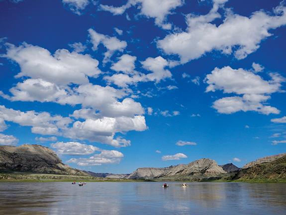
West of the rising moon and east of the Great Divide flows a still-wild stretch of the great Missouri River. Recently enshrined as the Missouri Breaks National Monument, this remote heart of Montana offers modern travelers a chance to experience a piece of the west almost as wild as it was in the days of Lewis and Clark. Although there are many ways to see it, most people prefer to float, either in canoes or sea kayaks.
With all the excitement around the upcoming 200th anniversary of the Lewis and Clark Corps of Discovery, it's a fine time to paddle the Breaks and see for yourself what's out there.
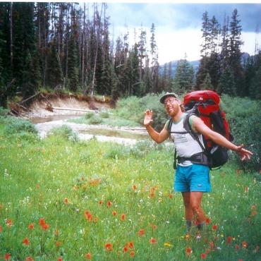
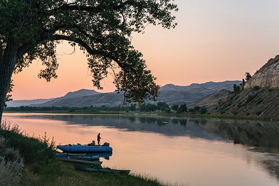
Last May my wife and I and two friends, Rick and Hugh, floated the full length of the Upper Missouri Wild and Scenic River, 149 miles from Fort Benton to James Kipp Recreation Area. Although this is doable in a week, we spent ten days out, with two of those days off-river—one for hiking and exploring, and one storm-bound.
Luck was with us at the put-in, as three weeks of cold, wet spring storms ended that day. Our first camp on the river was the peaceful paradise we had dreamed of for months.
Lewis and Clark traveled upriver through the Breaks from May 24 through June 13, 1805. You can still camp at sites where they stayed, and see much the same scenery, with the addition of various ruins and abandoned homesteads.
It’s hard to imagine traveling up this river under your own power. But Lewis and Clark and the intrepid men of the Corps of Discovery did just that, as most travelers did before the advent of steamboats on the upper Missouri in 1831. The Corps of Discovery required six dugout canoes and two keelboats to carry supplies and provisions for their party of 33. The smaller of their keelboats was 35 feet long and was designed to haul eight tons.
Lewis described the effort above Pablo Island, “The men are compelled to be in the water even to their armpits, and the water is yet very could, and so frequent are those points(s) that they are one fourth of their time in the water, added to this the banks and bluffs along which they are obliged to pass are so slippery and the mud so tenacious that they are unable to wear their mockersons, and in that situation draging the heavy burthen of a canoe and walking acasionally for several hundred yards over the sharp fragments of rocks which tumble from the clifts and garnish the borders of the river; in short their labour is incredibly painfull and great.”
Established by the American Fur Company in 1846, Fort Benton was the first settlement in Montana and the center of the area’s fur trade. Trappers used canoes, keelboats, mackinaws, and bullboats to haul fur and other trade goods to the fort. Steamboats reached Fort Benton in 1860, and could go no further upriver. The gold fields of Montana and Idaho were just about to explode in a frenzy of exploration and settlement, and many of the settlers and their supplies came up the Missouri. If you put in at Fort Benton be sure to check out the full-sized keelboat replica.
By far the most abundant wildlife you will encounter is birds. It’s a nearly endless parade of avian species, from white pelicans, geese, herons, cormorants, and ducks to golden and bald eagles, osprey, and red-tailed and Swainson’s hawks. We were treated to a sighting of peregrine falcons cruising the cliffs across from our camp near the Virgelle Ferry.
The upper Missouri provides habitat for 49 species of fish, including paddlefish and the endangered pallid sturgeon. Fishermen are most likely to catch goldeye, drum, sauger, walleye, northern pike, channel catfish, carp, and small-mouth buffalo. We encountered massive, frantically spawning carp in the muddy shallows, and saw a huge sauger jump across our bow like a dolphin.
Other wildlife you might see in the canyons include bighorn sheep (look to river right as you approach the CM Russell National Wildlife Refuge), elk, mule deer, coyotes, amazingly quick soft-shelled turtles (look at the mouth of Bullwhacker Creek), beaver, and black-tailed prairie dog.
As you ease your way downriver you will pass a variety of old forts and settlements, some of which retain significant structures. There’s a wealth of hiking and sightseeing to do among the ruins and rock formations. Take time to scramble up to the Hole in the Wall, a reputed hideout of Kid Curry, Butch Cassidy, and the Sundance Kid.
At the mouth of the Marias River (mile 22.7) try to picture which river you would have ascended in 1805. Lewis and Clark considered this dilemma from June 2-11. Had the captains followed the Marias upriver, the expedition might have failed.
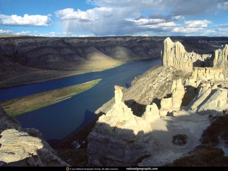
The Missouri Breaks are also rightly famous for their geology. Coal seams can be seen in many places. Soft sandstone forms an endless array of strange shapes, with dark volcanic dikes protruding as dark towers. Many of them are named: Pilot Rock, Steamboat Rock, Citadel Rock, Eagle Rock.
Of the famous White Cliffs, Lewis and Clark described “seens of visionary inchantment.” They wrote of “eligant ranges of lofty freestone buildings, having their parapets well stocked with statuary” and noted “nitches and alcoves of various forms and sizes are seen at different hights as we pass.”
You will also see distant mountains from many angles as you float long. These are the “island ranges” of the Highwoods, Bears Paw, Little Rockies, and Judith mountains.
If you continue beyond Judith Landing you will experience the lesser known but just as spectacular Badlands, called “Mauvaises Terres” by early French trappers. Beware of the incredibly sticky “gumbo” mud should you have wet weather.
Our final camp—for two nights—was at Bullwhacker Creek. On May 26 1805, Captain Lewis hiked to a high point above what he called Turtle (currently Bullwhacker) Creek. “...from this point I beheld the Rocky Mountains for the first time... while I viewed these mountains I felt a secret pleasure in finding myself so near the head of the heretofore conceived boundless Missouri; but when I reflected on the difficulties which this snowey barrier would most probably throw in my way to the Pacific, and the sufferings and hardships of myself and party in thim, it in some measure counterballanced the joy I had felt in the first moments in which I gazed on them;” The captains would not be deterred; they were west of the continental divide by late August and to the ocean by mid-November.
We however were near the end of our journey and by the next afternoon reached our vehicles at James Kipp Recreation Area. Ahead lay large meals, hot showers, and home. Times have changed... but in the Breaks you’d hardly know it.
Missouri River Logistics
The Missouri is a friendly river, accessible to intermediate-level paddlers. The most popular trip goes from Coal Banks Landing (mile 40) to Judith Landing (about mile 85). In 1994 my wife and I and another couple spent six cold, blustery April days backpacking along the northern shore of this section, taking in the spectacular White Cliffs area and ignoring the advice of the BLM ranger in Lewistown who told us “You can’t hike there! No one hikes there.” Still, this section in particular is best seen from the river, where you can drift along in sloth and comfort, gawking at the sheer spectacle of the Great Plains at its raw, unimproved best. All it lacks are some ornery grizzly bears, a few hundred thousand bison, and a pack or two of wolves to make ‘em run.
Although river maps show “rapids,” few if any of these present a hazard to a small boat like a canoe. The rapids were named and marked in the steamboat era, when swift, shallow areas were significant hazards to upriver boats. Probably the biggest hazard to modern boaters is weather and wind. During our May trip we were hit by three or four major rainstorms, one of which lasted over twenty-four hours and kept us pinned down in a camp which was reduced to a quagmire of gumbo.
Wind is a major factor on this river. Upriver winds may slow you significantly and even impede progress altogether. Allow “wind time” in your itinerary and get off the river if it’s too intense.
Forget about keeping your boat clean during the day. Getting in and out of the boat requires schlepping through mud on the riverbank. Plan on cleaning boats at day’s end after they are emptied. Knee-high rubber boots are a handy addition to camp wear (not to be worn in the boat, though—if you tip, they become anchors).
Boating regulations are minimal (unless you have a motor), and you can camp anywhere there is public land (although a lot of private land borders the river so make sure you know where you are). If possible, avoid camping near active bird nests in the spring. Try to minimize your impact, and burn only downed, dead wood. Pack out everything you pack in.
You must carry all your drinking water (one gallon per person per day), as the Missouri is basically mud too thin to walk across and will clog any filter in a hurry. There is no potable water at any landing along the river, unless you luck out like we did and catch the water delivery truck at Judith Landing.
It’s a good idea to carry a “honey bucket” (portable crapper) and may soon be required on some parts of the river—check with the BLM.
Detailed, waterproof maps including river miles, land ownership, topographic lines, etc. may be purchased at the Lewistown BLM Field Office, Fort Benton Visitor Center, Coal Banks Landing, Judith Landing, or the James Kipp Recreation Area.
Shuttle services are available for your car. It’s a long trip to shuttle vehicles yourself, especially if you’re doing the whole Wild and Scenic stretch. We paid about $150.00 per vehicle to a shuttle service in Fort Benton.
The average mid-summer current moves at 3.5 miles per hour. The average floater travels 20 miles per day. To plan, check current streamflow conditions and visit the BLM’s Missouri Breaks Monument website.