An App for That
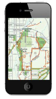
Ever wondered the best bike route to an in-town climbing boulder? Or been out with your dog and needed to drop a waste bag, pronto? Have you sought in vain for a comfy creekside bench to sit on and watch the water flow by? Well, now thanks to a new interactive digital map developed by Gallatin Valley Land Trust and Bozeman’s Department of Parks and Recreation, all these situations can be resolved right from your phone, while you’re on the trail. “We’ve always had a great paper trail map, but with today’s technology and mobile devices, people have been asking for a digital version,” says EJ Porth, GVLT’s communications and outreach manager. “It really allows trail users the ability to customize their experience and easily find new trails to explore.” Look for the app this summer and visit gvlt.org for more information.


