Gallatin Riverside Trail


Length: 5.5 miles (round-trip)
Duration: 2.5 hours
Difficulty: Easy
Elevation Gain: 200 feet
Activities: Hiking, fishing
Crowds: Moderate traffic
About
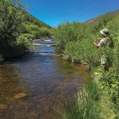
With looming cliffs overhead, lodgepole pines, and moss-covered boulders, this trail captures all of the area's beauty without the elevation gain. Enjoy a long, leisurely hike, watching the rafters and kayakers pass you by; or park a car at the Lava Lake trailhead and make it a quick one-way. Don't forget to bring a fly-rod to fish the pocket water. Carry bear spray.
Seasonal Conditions
This trail is open year-round, but be careful for high water during runoff season.
Directions
From Bozeman, take Hwy. 191 south toward Gallatin Canyon. When you get into the first section of tighter turns, watch for signs for Storm Castle Rd and the old concrete CCC bridge on the left. Cross the bridge and continue about 2 miles to the posted parking area. This parking area services three trails and is not very large. If it is full, more parking is available at the south end of the trail near the Lava Lake trailhead.

Map courtesy of Robert Stone's Day Hikes Around Bozeman, Montana.