Ski Tour: Texas Meadows


The southerly approach to Texas Meadows, via Wolverine Bowl
Approach Distance: 4.5 miles
Approach Gain: 2,200 feet
Skiable Vertical: 500 feet
Duration: 3 to 5 hours
Distance from Bozeman: 25 minutes
Avalanche Hazard*: Moderate
Traffic: Moderate
Overview
Sprawling across a prominent knoll between the south and middle forks of Brackett Creek, Texas Meadows offers a scenic half-day tour that's accessible from Brackett Creek trailhead, or from Bridger Bowl Ski Area if you have a pass. Atop the knoll you'll find stunning views of Ross Peak, Naya Nuki, and Sacajawea to the north, along with the striking limestone cliffs of Wolverine Bowl to the south. Texas Meadows packs a huge variety of terrain into a relatively small area, from low-angle, sparsely-treed meadows to deceptively steep shots and pillowy drops. Be cautious with your terrain selection—many of these steeper descents funnel into terrain traps near the base of Wolverine Bowl.
45.858679, -110.879771
Directions
From Brackett: Head up Bridger Canyon Road three miles past the turn for Bridger Bowl Ski Area. Turn right onto Brackett Creek Road and park in the pullout on the right.
From Bridger: Ride to the top of Alpine Lift and turn right off the lift towards the Bradley Meadows backcountry gate.

Approach
From Brackett: Cross Bridger Canyon Road from the parking lot and head up FS Road 631 (the road on the left) for 1.5 miles to the Lower South Brackett Trailhead. Turn left of the road and start up the trail, breifly rejoining the road before turning right at a sign marked "trail" (A). Continue up a gradual ridge through meadows and sparse trees, veering left (south) as the ridge begins to steepen. Skin up-drainage towards the unmistakable limestone cliffs of Wolverine Bowl.
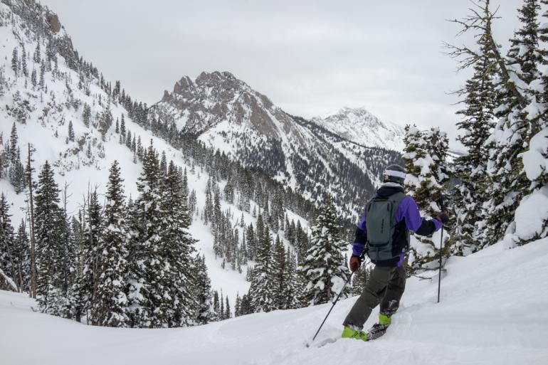
From Bridger: Head out the Bradley Meadows gate and up the skintrack to the top of the meadow. Veer left (west) at the top and drop down a low-angle, sparsely-treed gully (B) to the bottom of Wolverine Bowl. From the large clearing beneath Wolverine Bowl, skin up to a saddle between the Bridger Ridge and the knoll at the top of Texas Meadows (pictured below).

Descent
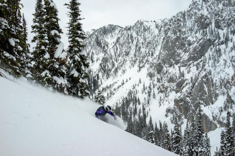
From the saddle, either ski down the opposite side you ascended, to the north toward Ross Peak (C), or back down the way you came up into Wolverine Bowl (D). Both of these descent routes follow low-hazard terrain through patches of trees and open meadows, with plenty of real estate for fresh tracks on every run. Many steeper descents exist from atop the knoll above Texas Meadows, but these slopes carry a much higher risk for avalanche, and hold several inconspicuous terrain traps. Regardless of your chosen descent, make sure you're confident in the snow stability before you ski.
If you're skiing back out to Brackett Creek, make sure you stick far enough to the left so that you don't wind up dropping into the Crosscut trail system.
The southerly approach to Texas Meadows, via Wolverine Bowl
Avalanche Safety
Despite its proximity to Bridger Bowl, Texas Meadows is a different beast when it comes to avalanche hazard. Unlike the Ridge terrain at Bridger, which is mitigated using explosives and only opened when ski patrol deems it safe, Texas Meadows is unadulterated backcountry. There is no avalanche control in this area, nor anyone to come help if you get buried (save for your partner). The descent options described here follow mellow terrain where a slide is unlikely, but these descents are closely abutted to steep, avalanche prone slopes on either side. Before heading to this zone, make sure you understand how to identify avalanche terrain, and how to decide whether to avoid it.
*Avalanche hazard refers to terrain risk only. Always travel with a partner and rescue gear, evaluate conditions carefully, and check the forecast before heading out.