Grab the Ram by the Horn
Hiking Buffalo Horn to Ramshorn Lake.
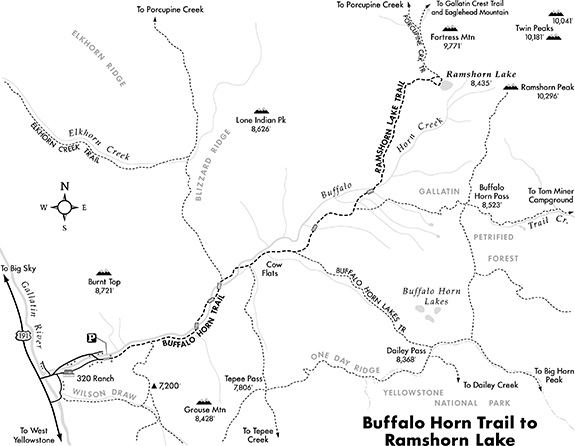
Ramshorn Lake sits at the base of Fortress Mountain and Ramshorn Peak, the highest mountain in the Gallatin Range at 10,289 feet. The circular lake, rimmed with pines, rests 1,800 feet below the towering peaks. It’s a popular fishing spot with cutthroat and golden trout. A few undeveloped campsites are located around the lake. The hike begins near the 320 Guest Ranch and follows Buffalo Horn Creek most of the way. The trail passes through lush meadows, spruce and lodgepole pine forests, and conglomerate boulder fields to the lakeshore.
Driving Directions
From Four Corners, take Hwy. 191 south toward Gallatin Canyon. Drive 46 miles to the posted 320 Ranch turnoff on the left at mile marker 36. (The turnoff is 12 miles south of Big Sky.) Turn left and continue about a mile into the mouth of the canyon to the upper trailhead parking area at the end of the road. En route, the road curves left and passes the 320 Ranch cabins.
Hiking Directions
Head east past the trailhead gate. Follow the south side of Buffalo Horn Creek up-canyon on the Buffalo Horn Trail. Stroll through the open forest and meadows between the creek on the left and multi-colored, vertical rock walls on the right. About half a mile in, there’s a posted junction. The right fork leads to Wilson Draw and Tepee Pass. Stay on the canyon bottom along the creek on the Buffalo Horn Trail. At just under a mile, cross a bridge over Buffalo Horn Creek and continue up-canyon. Cross another bridge over the creek, and meander through the grassland. Cross the creek again on a third bridge to a posted junction at 2 miles. The left fork leads two miles to Elkhorn Creek and eight miles to Porcupine Creek.
Continue straight ahead, staying on the Buffalo Horn Trail as Fortress Mountain and Ramshorn Peak come into view. Drop into Cow Flats, a vast meadow, and cross a bridge over the creek. Walk through the open flats, passing a junction on the right that leads 2.5 miles to Tepee Pass. Rock-hop over the creek and head up the hillside. Follow a minor ridge and moderately climb, passing the Buffalo Horn Lakes Trail on the right. Cross a bridge over a fork of Buffalo Horn Creek, and climb through a meadow to a Y-fork. The right fork leads two miles to Buffalo Horn Pass and the Gallatin Petrified Forest.
Go left on the Ramshorn Lake Trail, and cross a bridge over a fork of Buffalo Horn Creek. Cross two more log bridges, and rock-hop over the creek. Pass a seasonal pond on the left. Climb through the meadow, with Ramshorn Peak and Fortress Mountain looming over the trail. Curve east, weaving through the forest as the grade gets steeper. Walk through a meadow to a Y-fork. Both forks lead to Ramshorn Lake. For this hike, veer left and descend to the base of Fortress Mountain’s jagged vertical wall. Pass horse corrals to a junction. The Porcupine Creek Trail goes left (north) toward Eaglehead Mountain. Bear right and descend to the north end of circular Ramshorn Lake. After enjoying the lakeside area, return by retracing your steps.
Vitals
Hiking distance: 13 miles round trip
Hiking time: 5-7 hours
Elevation gain: 1,800 feet
Maps: U.S.G.S. Sunshine Point, Lone Indian Peak, Ramshorn Peak;
Beartooth Publishing: Big Sky

This trail description was adapted from Day Hikes Around Bozeman by Robert Stone.


