Hell or High Water

A solo paddleboarding odyssey on the Yellowstone.
Something big was in the works—big enough that I needed a first bite before mustering an appetite for the whole thing.
That thing was the proverbial “Old ’96er,” for fans of John Candy and The Great Outdoors—which, in my case, didn’t mean eating a massive steak, but rather paddleboarding the massive full length of the Yellowstone River. My first bite—or rather, mouthful—was a certain 126-mile stretch, made in one long, sustained push. As it turned out, it was enough to taste the juice and know that I wanted more. Maybe someday I can pursue my real goal, taking it all the way to the gristle, and only then might have cause to crack open the Mezcal. In the meantime, I’m still relishing the solitude and sense of accomplishment from one particular spring day under the Big Sky.
The Gauge
Many paddlers out there are fitter than I was, and had gone farther and faster, covering more distance on flatter water. Their records on the river are well-known. But this trip wasn’t planned with a certain number of miles in mind. Instead, it was about solving the logistical riddle of how far someone could make it on the Yellowstone, starting from its mountainous and turbulent headwaters at the national-park boundary in Gardiner, and taking it into the “big flat” of plains and ranches of south-central Montana in a day. It was an exploratory solo adventure, not a race.
Regardless, the trip required careful timing, and this particular season was an odd one. I spent every morning checking the stream gauges. Our lack of snow accumulation in the traditionally banger months of mid-winter was worrisome at first, but the rebound of springtime snow in higher elevations had me living like a felon: go-bag at the door, ready to flee. (Hopefully after kissing the wife and kids goodbye.)
The key mark was 15,000cfs on the Corwin Springs gauge. Much more than that would distract the river from a linear trajectory in the flatter sections, squeezing the laminar flow with boils. Lesser flows, however, would make it difficult to navigate the lower Yellowstone’s barely-covered islands, with their rocks ready to break a fin. So, when 15k finally showed up on the gauge, I was out the door, driving 80mph at 4am toward Gardiner, with a 12-foot, 6-inch inflatable board hanging out of my short-bed truck.
For the roaring, muddy Yellowstone, an inflatable whitewater paddleboard could handle the first 20 miles with ease, even at the crunchy river levels of 15,000cfs. But it would go nowhere fast when the gradient dropped and the water leveled out.
The Craft
At first glance, even if you aren’t a watersports enthusiast of any sort, the answer to my logistical riddle of starting and finishing with daylight seems simple: paddle. You would be right. Continuous paddling for 13 hours and 30 minutes was the solution. But there was a more restrictive issue: the craft.
Solving the problem for this river was akin to choosing a bike for a race with both burly mountain-riding for the first section and 100 miles of road-racing at the end. Absurd, I know—not even a top-notch gravel bike would perform well in such a range of conditions.


For the roaring, muddy Yellowstone, an inflatable whitewater paddleboard could handle the first 20 miles with ease, even at the crunchy river levels of 15,000cfs. But it would go nowhere fast when the gradient dropped and the water leveled out. The same could be said with a carbon race board, but the opposite way—gnarly whitewater would be an issue.
So, I settled on an inflatable race/tour board, even though it would feel like standing on a basketball through the hard stuff. As a whitewater paddleboarder at heart, I embraced the thrill of taking on the Yellowstone’s two major whitewater sections on a skinny, unstable board at high water.

The Purpose
In short, my mileage goal alone meant little. Someone could put in below the worst of the whitewater with a carbon race board and crush my time. In fact, I could do that and crush my own time, so long as the board didn’t break on the innumerable gravel bars, trees, and boulders hiding just a few inches below the muddy ripples. No, instead, there was something about starting where the river begins that had a deep appeal (although a true source-to-confluence run of the Yellowstone River would be illegal, due to the Park’s watercraft restrictions). Launching in Gardiner was the closest thing, and jumping into the 50-degree river alone at 5:45am to face seven-foot-tall wave trains… well, it just felt right.
There was something about starting where the river begins that had a deep appeal.
The Paddle
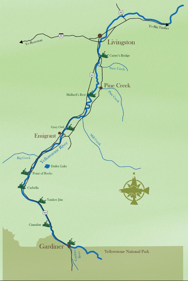
Gardiner to Yankee Jim
At 5:30, I walked down the steep, winding dirt road to the put-in. A glow from the sun’s rosy-fingered reaches illuminated the hills. I set the board down in the water just below the Gardner River’s confluence, taking in the curling waves that characterize the Town Stretch under the bridge, then set off.
The river here flows through a landscape framed by rugged mountains and the thermal activity of the Yellowstone Caldera. Of this segment’s 13 miles, the first two were the most exhilarating. Town was still quiet, except for the yips of a fox patrolling the shoreline as I entered the Class II & III rapids, bouncing my way north into flatter, though still very fast, water.
Yankee Jim to Emigrant
Yankee Jim Canyon, about seven miles downriver from Gardiner, holds a rich history that dates to the late 19th century. The canyon is named after James George, known as “Yankee Jim,” a notorious figure known to have fought bears, wolves, and maybe the occasional mountain lion to protect his homestead. George established a toll road through the canyon in the 1880s, charging travelers, including early tourists heading to Yellowstone Park, for passage, and was visited by the likes of Teddy Roosevelt and Rudyard Kipling due to his notoriety.
While Yankee Jim and his toll are long gone, the restriction to passage that he set forth lives on in the form of high water—making the canyon difficult even for worthy raft captains. The canyon’s four named rapids—Yankee Jim’s Revenge (featuring the infamous Boat-Eater wave), Big Rock, the Pinch, and Box Car—are fully in at 15,000cfs, and as such were ready to flip anything not pointed right into their meat.


Remaining standing through all of Yankee Jim’s rapids on a whitewater board is an accomplishment that many paddleboarders in Montana have worked hard at, doing multiple laps on hot summer days. However, on my long, narrow board it felt more like rolling the dice. I managed to make it through the main drops standing, but was thrown into the water by Boat-Eater when the careening flows halted in standstill boils. It was then that I saw my first onlookers from the road, and I wouldn’t have been the slightest bit surprised if they considered setting off a search-and-rescue alarm at the sight of someone paddleboarding the canyon alone at dawn. The best of the three rapids, Box Car, was in great form at that flow, and although I tried to punch through it, the standing wave held me in place, surfing me backward a while until finally spitting me out. After that, from a gradient perspective, the worst was behind me—at least that’s what I thought.
I unclipped my leash and paddled like hell 45 degrees against the flow, knowing that if I fell, I would be sucked into a horrible hydrological feature.
Emigrant to Livingston
Beyond Yankee Jim, the river enters the expansive Paradise Valley. This stretch of river offers a serene paddling experience with panoramic views of the Absarokas on the right and Gallatin Range on the left. The valley’s name is well-deserved, as verdant meadows stretch out on either side of the river, dotted with rustic ranch houses and corrals. The sky here seems endless, often filled with the soaring silhouettes of eagles and other birds of prey.
Deer and elk graze near the river, especially in the early morning and late evening. Black bears, though more elusive, occasionally forage the shoreline forests. Beavers and river otters are residents of the river, their presence marked by the lodges and dams they construct in the less-active braids of the river. These animals add to the richness of the paddling experience, offering glimpses into the lives of the fascinating creatures with whom we share these waterways.
Running low on water, I stopped at two of the tributaries that enter the river in Paradise Valley—Mill Creek and Pine Creek—quickly filling my bottle from the clean snowmelt, rather than the Yellowstone’s agricultural runoff.
Livingston to Springdale
After passing through Livingston without incident, I encountered the most hazardous part of my trip: navigating the Highway 89 bridge. While I’m not an engineer of any sort, my philosophical brain wonders what the logic was in creating what can only be described by human and history alike as a death-trap.
Here, the river makes a 90-degree right turn followed by an immediate 90-degree left turn. Smack dab in the middle of this hydrological conundrum is the bridge. What the double-banking does at high water is send the predominant flow diagonally into, and through, two sets of bridge pylons rather than safely between them. I unclipped my leash and paddled like hell 45 degrees against the flow, knowing that if I fell, I would be sucked into a horrible hydrological feature. I didn’t know the story of two locals drowning there in 2018 due to a capsized driftboat, but have since told many casual boaters to beware and consider putting in below the deadly overpass.
Below Hwy. 89, the river widens and flattens out, cutting through layers of volcanic and sedimentary rock on its left bank, revealing millions of years of history. You can see it in the shoreline, with cliffs and outcrops that tell a story of ancient geological activity, tectonic shifts, and the relentless force of erosion.
Additionally, the same processes can also be observed in the water features, with significant surf waves and wave trains appearing where the current is forced up and over rock benches in the river floor. While Springdale Wave takes the cake in terms of access and size on the Yellowstone, this section of river had one mega-wave that I hadn’t seen before, and it gave me a real run for my money.

Springdale to Reed Point
Passing one more great surf wave at Greycliff—throwing the river’s “brown claw” into the lineup—I soaked in observers’ cheers, knowing the end was near—my end, that is. Nowhere, really, close to the actual end.
Here I said goodbye to the mountain ranges that had loomed over the river earlier in the day. The Absarokas, the Bridgers, and even the Crazies now left my company, and the light was beginning to soften but not yet glow. It was here that the sky above became filled with an almost rush-hour-like traffic of the winged sort.
The Yellowstone River corridor is a bird haven, especially in this section, with ancient cottonwoods acting as watchtowers for eagle convocations. The river’s riparian zones provide essential habitats for these birds, making it a vibrant and lively ecosystem. I saw countless bald eagles, golden eagles, cormorants, and ospreys, their nests perched high in the trees along the riverbank. Great blue herons, sandhill cranes, and a variety of ducks and other waterfowl also flew overhead as I paddled into the growing stillness.
The Journey’s End
Approaching Reed Point, the landscape changes once again. The river meanders through rolling hills and wide-open plains. A small community known for its annual sheep drive, Reed Point marked the conclusion of my paddling adventure. Here, the river’s influence on local life is evident in the agricultural fields and the strong sense of community among its residents.
I pulled up to the shoreline just above a spin fisherman casting into a big eddy. He remarked that I was the only paddleboarder on the Yellowstone, and while that wasn’t exactly true, part of it resonated, having just spent the last 126 miles alone. Paddler or not, most of the day had felt like I was the last person on Earth.


Paddling the Yellowstone from Gardiner to Reed Point was not just a journey through Montana’s stunning landscapes; it was a voyage through time and nature. From the towering cliffs of Yankee Jim Canyon to the tranquil meadows of Paradise Valley, from encounters with wildlife to sites of historical significance, these stretches of the longest free-flowing river in the Lower 48 offer paddlers an experience that captivates the senses and enriches the soul, whether they are linked together or paddled separately. I am excited to see what is around the final corner I left unturned, and hope to return for the “full bite” someday soon—gristle and all.
Smaller Bites
by the editors
If you’re looking for a smaller bite of the Yellowstone than a 130-mile epic, you’re in luck. The river is peppered with FWP- and BLM-maintained boat ramps, where you can launch a watercraft, take a few casts, or just go for a dip. Here’s a selection of popular day floats on the upper river.
Whitewater World—Class II-III
Gardiner to Cinnabar
Test your paddling skills with an exciting eight miles of low-stakes whitewater (at most flows). Put in at Confluence Park in Gardiner, then paddle the town waves and try not to swim. After McConnell beach, there’s nothing but flat water and good times. Take out at Cinnabar Picnic Area on river left right before the bridge.
Big-Wave Rave—Class III-IV
Yankee Jim to Carbella
Once you’ve mastered the Gardiner town section, spice things up with a wild, four-mile ride through Yankee Jim Canyon, where you’ll face the Yellowstone’s biggest rapids: Revenge (featuring the infamous Boat-Eater wave), Big Rock, the Pinch, and Boxcar. Dress warm and leave some bootie beers in the shuttle rig, because you’re sure to swim (especially at high water). Take out at the Carbella boat ramp on river right after Tom Miner Bridge.
Lip-Ripper’s Paradise—Class I
Point of Rocks to Grey Owl
The preferred float for fishermen looking to make the most of an afternoon, this 12-mile stretch of river is loaded with both fish and fishable water. Take out at Grey Owl on river left after passing through Emigrant. While running shuttle, be sure to stop at Follow Yer’ Nose for some cold beer and good BBQ.
Booze Cruise—Class I
Mallard’s Rest to Carter’s Bridge
If you’re new to the world of river-running or just prefer tossing back a couple of cold ones at a leisurely pace, this 12-mile float is right up your alley. It’s best done in July and August, once the water temps have warmed up. Pick a designated driver, and head straight from the take-out to Pine Creek Lodge for live music afterward.