Blackmore Lake Trail


Length: 4 miles (round-trip to the most popular turnaround), 12 miles (round-trip to the top of Mount Blackmore)
Duration: 2 hours to all day
Difficulty: Moderate to hard
Elevation Gain: 640 to 3,590 feet
Activities: Hiking, trail running, camping, skiing
Crowds: Moderate traffic
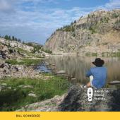
About
Blackmore Lake Trail begins near the northwest edge of Hyalite Reservoir. Blackmore Lake lies beneath Mount Blackmore and Elephant Mountain, surrounded by meadow and dense pine forest. With several route options, this hike can be extended an additional 4 miles to the top of Mount Blackmore, and more ambitious hikers can continue another 11 miles to the S. Cottonwood trailhead, where they can drop a shuttle vehicle. Carry bear spray.
Seasonal Conditions
This trail is popular year round, but especially in winter among cross-country skiers. The Bridger Ski Foundation periodically grooms the lower section of this trail, and it is a popular starting point for tours around Hyalite. Backcountry skiers and summer peak-baggers also use the trailhead for accessing Mount Blackmore.
Directions
Head south on 19th Ave. and turn left on Hyalite Canyon Rd. Trailhead parking is located to the right, just before you reach Hyalite Reservoir.

Map courtesy of Robert Stone's Day Hikes Around Bozeman, Montana.
45.48727741015, -110.98183444922