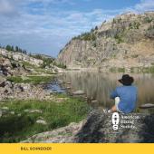
Prospectors’ Peak

Profiling Emigrant.
The grandeur of the Western Beartooths has always astounded travelers in Paradise Valley bound for Yellowstone. Even while the deep gorges and jagged skyline above the lower valley inspire awe, oglers cannot help but notice the monstrous massif of Emigrant Peak on the southern skyline. As they advance into the upper valley, closer inspection only confirms that the mountain they saw from a distance is indeed extraordinary.
Emigrant Peak rises 6,000 feet from the Yellowstone River to a steep-sided summit knob. Clearly circumscribed by Paradise Valley to the west, Emigrant Creek to the east, and Sixmile Creek to the south, Emigrant has a circumference at its base of over 20 miles.
The mountain is impressive not only for its massive girth, but also because the summit towers a mere three horizontal miles from the western base of the mountain at the Paradise Valley flats. It owes this bulk and eminence to the coincidental juxtaposition of an Eocene volcanic conduit with the dramatic Deep Creek fault. The stage was set during the Laramide orogeny when sedimentary beds in the Emigrant Peak area were splintered and tilted upward into a northward sloping highland. Then, between 60 and 53 million years ago, volcanoes in the area spewed layer upon layer of molten andesite lava, completely burying the sedimentary beds beneath an enormous volcanic plateau. The critical event in the evolution of the topography we see today was the cataclysmic intrusion of granodiorite magma forming what some geologists believe was an Eocene caldera centered just east of today’s Emigrant Peak. This giant volcano spewed lava and ash throughout the northern ecosystem about 53 million years ago. Long after the caldera became dormant, continental extension activated the Deep Creek fault just west of the solidified igneous conduit. In the last two million years, the western side of the fault dropped over 10,000 feet and filled with sediment to form Paradise Valley, while the southern part of the range uplifted east of the fault nearly 10,000 feet. Stream erosion and Pleistocene glaciers subsequently eroded away thousands of feet of volcanic debris, exposing the resistant stock of Emigrant Peak strikingly close to Paradise Valley.

The igneous intrusion that eventually would comprise Emigrant Peak also furnished excellent conditions for the formation of precious-metal deposits. In late fall of 1863, pioneer prospector Thomas Curry discovered gold dust in a creek flowing northward from the east side of Emigrant Peak. Indians chased him away that year, but he returned to prospect the following spring with a large party. Most of this group, however, abandoned what they called “Curry’s Gulch” and continued up the Yellowstone for better prospects. Meanwhile, in late April 1864, trapping legend Jim Bridger piloted a wagon train of would-be prospectors from Fort Laramie to the burgeoning gold mines at Alder Gulch, near Virginia City. At least two other wagon trains had a similar purpose, one of which John Bozeman commanded. Aware of this incoming hoard of well over 1,000 emigrants, Curry met Bridger’s train at the mouth of Shields River and coerced 30 men to accompany him back to Curry’s Gulch. Although an army of 600 Indians denied this group access, Curry persisted throughout that summer. News of additional gold discoveries in the gulch by David Shorthill and David Weaver drew enough prospectors by August that a small village developed at the mouth of Curry’s Gulch. By spring of 1865, Yellowstone City had 40 cabins and supported some 300 migrant gold diggers. Curry’s Gulch was soon renamed “Emigrant Gulch” for this influx of people and the mountain at its head earned the name “Emigrant Peak.” Indian attacks and an arduous winter left Yellowstone City virtually abandoned by spring of 1866, but not before the “city” dispatched many prospecting parties for adventures throughout the Beartooths and Northern Absaroka. Dredge mining in Emigrant Creek later obliterated all traces of Yellowstone City.
Although it was coined in 1864, the name “Emigrant Peak” was not published on an official map until E. Hergesheimer placed it on Hayden’s “Parts of Idaho, Montana, and Wyoming” map in 1872. Emigrant Peak was probably first climbed by settlers or prospectors as early as 1864, but the first recorded ascent was made on August 28, 1871 by two members of the Hayden Survey—Albert C. Peale and Henry Elliott. After a glorious circumnavigation of Yellowstone Lake, the ascent was made with remarkable speed during the party’s egress to Fort Ellis. Peale wrote of his experience on the mountain:
This morning Elliott and I rose early, took breakfast at 4am, and started to go to the top of Emigrant Peak. I rode Beaman’s horse. We forded the Yellowstone and rode our horses to the elevation of about 8,000 feet and then dismounted and unsaddled, tying them to a tree. After we left our horses we had a very steep climb over a slide of volcanic rocks and over the snow, or rather ice, for such it is. After a tough climb through two gorges, I arrived near the summit and the rest of the way was easily gone over. Elliott reached the top long before I did... We were told before we started that it could not be done, and indeed, by any other route than we took, it was impossible.
Emigrant Peak’s prominence and position made it an important landmark for future surveys of Montana and Yellowstone. Surveyors John Renshawe or H. S. Chase climbed the peak between 1882 and 1884, and Edward Douglas revisited the station between 1886 and 1888. Joseph Iddings thoroughly investigated the geology of the mountain in July 1890, possibly reaching the summit as well. USGS surveyors again made the ascent in 1936, followed by Ector B. Latham in 1950.
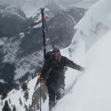
Modern mountaineers on Emigrant Peak have focused on ski mountaineering, and rock climbing on a pair of biotite-schist buttresses in Emigrant Gulch. Rubber Hose Buttress rises above the first pullout after the steep grade of bulldozed talus about a mile south of White City along Emigrant Gulch Rd. (Forest Rd. #3272). It offers a half-dozen moderate crack and face climbs one or two pitches in length. The Phat One is a 700-foot steep slab above the second pullout on Emigrant Gulch Rd. Many moderate and difficult variations are possible on this route, but the dearth of protection relegates them to experienced and bold climbers only.
Ascent A
The standard approach to Emigrant Peak begins near the mouth of Sixmile Canyon at Gold Prize trailhead west of the mountain. Three miles south of Emigrant, turn south off East River Rd. onto Dailey Lake Rd. Drive for 3.3 miles and turn left onto Sixmile Canyon Rd. (Forest Rd. #348). Drive 1.7 miles into the canyon and turn left onto a faint road before the crossing of Gold Prize Creek. Follow this road for one mile to its end at a gate and an old cabin. Hike along the north side of Gold Prize Creek on an old logging road for about one mile, and then follow the trail as it turns left up a steep draw on the old roadbed. The trail climbs steadily up the draw for about one mile, then merges with another old road. Follow this road for about a half-mile as it traverses east across the forested south slopes of one of Emigrant’s lower western ridges. When the road contours in and out of a draw, leave the road to the left and climb a well-worn singletrack trail up a steep slope. This trail leads directly to the top of a hill and a large meadow at the base of Emigrant Peak. Hike to the northeast side of the meadow to gain the lower west ridge of Emigrant and follow an odious barbed-wire fence up the ridge. Stay on the steepening ridge through a long stretch of forest and finish the ascent with 1,500 feet of fun and easy rock scrambling. The route follows mostly the north side of the ridge along an extended series of diagonal ledges that interconnect to form natural switchbacks.
Ascent Vitals
Gold Prize parking elevation: 6,234 feet
Elevation gain: 4,687 feet
Distance: 6 miles
Estimated ascent time: 4 to 7 hours
Maps: Dailey Lake, Emigrant Peak
Ascent B
To approach the east side of Emigrant Peak, drive 1.5 miles southwest from Chico Hot Springs and turn left into Emigrant Gulch at Chico. Drive 2.5 miles through White City and cross Emigrant Creek on a bridge. Only high-clearance four-wheel-drive vehicles should attempt to continue beyond this bridge. Mountain bikes are an excellent alternative for the first few miles until the road becomes consistently steep and rocky. After the bridge, the road traverses a precarious bulldozed talus slope and after 2.5 miles, begins a series of about 20 switchbacks up the east side of the peak. In early spring, most of this terrain will be covered by snow. Ski mountaineers may climb to the summit from basins on both the southeast and northeast sides of the peak. Both aspects offer spectacular ski terrain.
Ascent Vitals
White City bridge parking elevation: 6,120 feet
Elevation gain: 4,801 feet
Distance: 8 miles
Estimated ascent time: 4 to 7 hours
Maps: Emigrant Peak
This is an excerpt from Select Peaks of Greater Yellowstone: A Mountaineering History and Guide, published in 2003 by Thomas Turiano, who writes and guides from his home in Wilson, Wyoming.