High Over Paradise
Hiking to Pine Creek Lake.
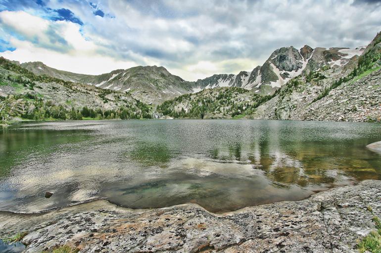
Pine Creek Lake is a pristine alpine lake in a huge, 9,032-foot basin high above Paradise Valley. The 31-acre lake sits in the glacial cirque on the north slope of Black Mountain, which towers 900 feet above the lake in the Absaroka-Beartooth Wilderness. The strenuous but well-defined trail climbs past a series of spectacular waterfalls (including Pine Creek Falls) and a couple of smaller lakes to Pine Creek Lake. En route are vistas across Paradise Valley to the Gallatin Range.
Vitals
Hiking distance: 10 miles round trip
Hiking time: 6 hours
Elevation gain: 3,400 feet
Maps: U.S.G.S. Dexter Point and Mount Cowen
Driving directions: From Livingston at the I-90 and Hwy. 89 junction, drive 9.6 miles south on Hwy. 89 to Pine Creek Road on the left, between mile markers 43 and 44. Turn left and continue 2.4 miles (crossing over the Yellowstone River) to East River Road. Turn right and drive 0.7 miles to Luccock Park Road on the left. A sign is posted for the Pine Creek Campground. Turn left (east) on Luccock Park Road, and wind 3.1 miles up the foothills to the trailhead parking area at road’s end (0.6 miles past the George Lake turnoff).
Hiking directions: Take the posted trail from the far end of the parking area. Immediately enter a deep, lush forest to a junction. Stay to the right on the Pine Creek trail. At a quarter mile, pass a junction to the George Lake Trail on the right. Cross a bridge over Pine Creek at 0.5 miles, and enter the Absaroka-Beartooth Wilderness. Continue along the north side of the cascading creek to a second bridge over Pine Creek at just over 1.1 mile. From the bridge is a dramatic view of towering Pine Creek Falls. Thirty yards beyond the bridge is a side shoot of the waterfall. Several unmaintained trails access the upper chute of the falls.
Continue on the main trail past the bridge, and cross downfall logs over the south channel of the creek. Zigzag up the hillside to a view down canyon of Paradise Valley. A side path on the left leads 30 yards to the brink of the falls at the narrow rock chute. The main trail follows the cascading creek, steadily climbing past huge granite boulders. The rock-embedded path leads to the creek at just under 2 miles, with a view of a 200-foot waterfall upstream.
Carefully cross the creek on downfall logs and rocks to the north side of Pine Creek. Curve left, away from the creek. Loop around the mountainside, crossing a northern tributary of the creek. Climb more switchbacks beneath the jagged spires on the north canyon wall. Return to Pine Creek and a waterfall. Follow the cascading whitewater past a series of falls. Curve away from the slope, and zigzag up the rocky slope through a scree field. Skirt the edge of a vertical rock wall beneath the crowns of Mount McKnight and Black Mountain. Top the slope and enter a forested cirque with another 200-foot waterfall. Descend to the creek and follow it upstream. A side path on the right leads to a campsite by a small lake and a full view of the waterfall.
Veer left and climb five switchbacks to another view of the falls and the lake below the rock-walled bowl. At the top of the rock face, the trail overlooks Jewel Lake and the cascade feeding the tarn. Descend to the end of Jewel Lake. Follow the west shore and cross the outlet creek 20 yards upstream from the falls. Bear left and continue past the lake, climbing out of the bowl. Pass two waterfalls filling a pool just above Jewel Lake. Above the falls, the trail reaches broad slabs of granite rock that line the north shore of gorgeous Pine Creek Lake. Another waterfall feeds the south end of the lake. After enjoying the views and a well-earned rest, return along the same route.
This article is excerpted from Robert Stone’s Day Hikes in the Beartooth Mountains.

